
European satellite navigation system Galileo supports European agriculture in its 4.0 journey
Galileo is a civil satellite navigation and positioning system (in English GNSS – Global Navigation Satellite System), developed in Europe as an alternative to the Global Positioning System (NAVSTAR GPS), controlled instead by the US Department of Defence. Since it was declared operational in 2016, the Galileo system has been going from strength to strength, steadily increasing the number of available satellites in space. The more satellites one has, the more robust the service provision becomes. The number of satellites in the Galileo constellation is now equal to 26, orbiting on three planes inclined to the Earth’s equatorial plane, at an altitude of 23,925 km. The system is able to provide a degree of accuracy of a few centimeters in the three directions (longitude, latitude, altitude) resulting in a better and more accurate service than other positioning systems, with significant positive implications for many European services and users. Products that people use every day – from their car navigation device to their mobile phone – benefit from the increased accuracy provided by Galileo. Critical emergency response services also benefit from Galileo.
Galileo for autonomous driving of agricultural machinery
The advent of autonomous driving in agriculture has led machine manufacturers to choose positioning and navigation systems to be mounted on board. In many cases, non-satellite systems are used: the machines are equipped with sensors capable of detecting precise areas of the plot (or crop) such as to allow semi-automatic driving of vehicles along optimal routes. The sensors used are mainly optical and radar sensors, lidar sensors or 3D cameras that detect furrows or swaths and, through real-time image analysis, correct the tractor’s trajectory according to the operation. The choice not to use satellite systems is due to the fact that these in themselves do not ensure centimeter accuracy of indications. This changes when satellite signals are integrated with Realtime Kinematics (RTK) solutions. This integration provides important benefits and opportunities for autonomous machines in the agricultural environment, greatly improving the accuracy of movements and enhancing the overall functionality of the assets. What does this integration consist of? In the use of a system of two or more satellite signal receivers, at least one of which is fixed, whose position has been determined geodetically and by other means with the highest precision. This receiver with known and precise coordinates is able to constantly correct the signal received from the satellite relative to its position and transmit the correction to the mobile receivers to which it is coupled. Based on this data, mobile receivers, e.g. those on self-driving robots, can correct their position, achieving centimeter accuracies.
High precision with real-time kinematics
The French company Agreenculture made just this choice: it has integrated Galileo signals as part of its autonomous agricultural robotic solution to improve the computed trajectories. The glocalization system developed by Agreenculture is based on a fixed base station with known coordinates and a box (called AGC Box) with a satellite receiver that is placed on the self-driving vehicle. The AGC Box then recalculates the trajectories sent to it by the satellite signal based on the indications of the fixed station, within a predefined space (the field or vineyard) and on the basis of a positioning algorithm developed by Agreenculture, which allows centimetric accuracy in autonomous driving.
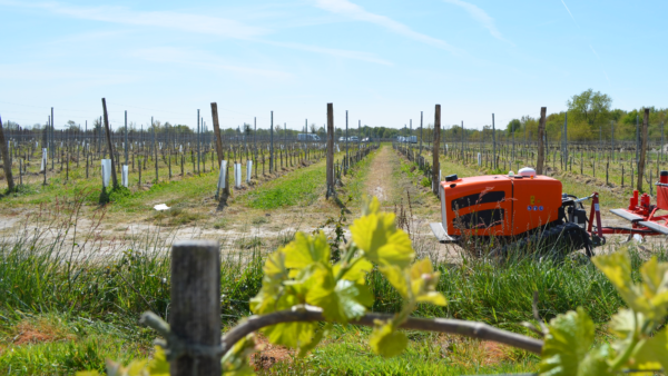
The Agreenculture robotic solution
The AGC Box developed by Agreenculture can in theory be placed on any machine that is to be automated because it is independent of a specific model. However, an autonomous robot called CEOL has also been developed in Agreenculture. This is a small tractor equipped with a category 1 lift, allowing it to be adapted to different equipment.
It can carry or tow a range of different sized equipment and thus robotize much of the work currently carried out with a tractor. Its hybrid (diesel-electric) motorization system allows diesel consumption to be reduced by a factor of 4 compared to a conventional tractor carrying out the same tasks. The robot is smooth and lightweight, which minimizes furrows, making operations possible in shorter time windows and even difficult soil conditions. CEOL moves autonomously thanks to the AGC Box system but is also equipped with LIDAR sensors to detect obstacles and adjust the speed of the robot. In order to define the space within which CEOL is to move, Agreenculture offers two modes: a manual one, with a radio command, and an automatic one that first requires a survey of the terrain and a definition of the space within which the robot can move. These steps ensure that the robot only moves within the defined limits, which could correspond to the boundaries of the vineyard, for example. The AGC Box not only serves as a satellite signal but, thanks to a series of algorithms, makes it possible to robotize operations: it supervises and ensures the execution of work, calculates the best routes, avoids obstacles and draws maps that are then used by CEOL to optimize its trajectory.
Maria Luisa Doldi
Advantages of satellite navigation in agriculture
The case of Agreenculture shows how satellite navigation technology, in particular the European Galileo system, can become an important ingredient of the agricultural robotics revolution. The improvement of the mapped trajectories is equivalent to optimized and more accurate routes for autonomous machines, to greater safety and reliability for them. This means both environmental benefits – reductions in fuel, water, pesticides and emissions – helping European agriculture to become more sustainable and competitive, and a reduction in the work of the farmer, who can delegate some tasks to the machines and concentrate on tasks where human labour is irreplaceable. This experience also shows how on the basis of a tool available to everyone – the Galileo system – new tools can be developed for agriculture. Finally, as Agreenculture states, the introduction of the Galileo constellation has improved the accuracy of the positioning solution, especially in environments where the satellite signal is weak, such as dense forests or under trees with dense foliage, connecting areas or applications that were otherwise excluded to the robotic revolution.


